|
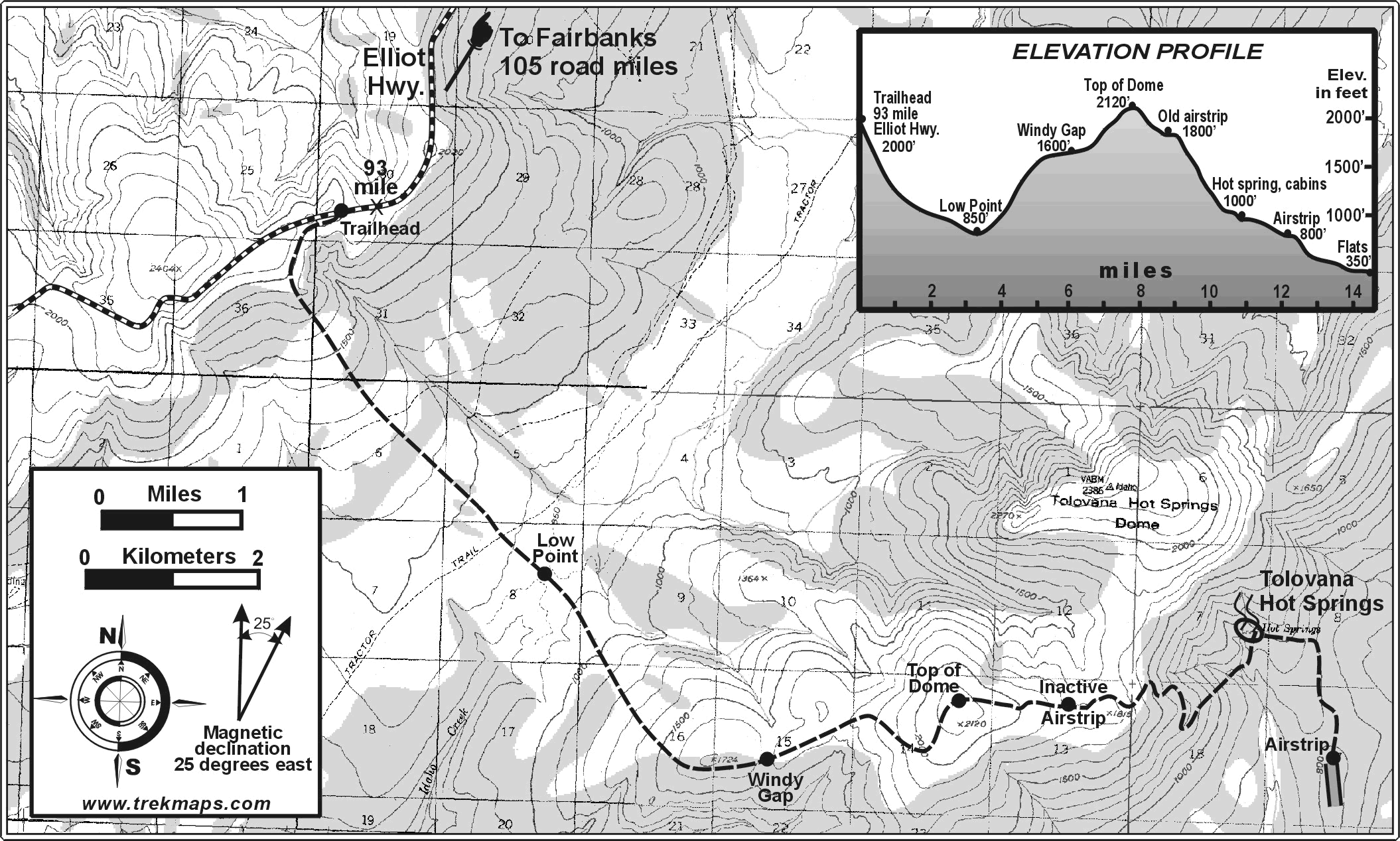
The springs are located approximately 45 air miles northwest of Fairbanks on the southeast slope of Tolovana Hot Springs Dome (see USGS Livengood B-4 topographic map, Delorme Alaska Atlas page 124, or see map.
Tolovana Hot Springs Ltd. does not own or maintain the access trails described here. We can help visitors with directions and reports of recent weather and trail conditions, but cannot guarantee conditions or visitors’ ability to use the trails. Trail users should be prepared for a wilderness journey. THS recommends users have backcountry experience.
THS may be able to arrange guided trips to and from the hot springs. Please call or e-mail for additional information. Advance planning is required and guiding services are not inexpensive and reservations must be secured for the guide(s).
10.1 Mile Trail (winter and summer hiking)
Primary access is by the 10.1-mile year-round trail suitable for hiking, skiing, snowshoeing, skijoring, and snow machining. The trail is characterized by long moderate slopes with some steep sections. The trail crosses over Tolovana Hot Springs Dome, from which travelers enjoy spectacular views of Minto Flats State Game Refuge, the White and Ray Mountain Ranges and, on clear days, Mount McKinley, 200 miles away.
Dog-mushers and skiers must be skilled and exercise care on the steep hills. A 3 mile stretch of low-lying terrain is boggy in the summer. Use of 4 wheelers has caused serious damage to this stretch and to some upland areas. Use of 4 wheelers to access the hot springs is not supported. The steep terrain and boggy section make for very difficult mountain biking.
The trailhead is 100 road miles from Fairbanks on the Elliot Highway (milepost 93).
26 Mile Trail (winter only)
This trail allows winter access by dog-mushing, snow machining, skiing and winter biking. Most of the trail follows the long, straight flat stretches of the historic Livengood-Dunbar Sled Road down the Tolovana River valley. This trail was built in 1917 to support gold mining activity in Brooks (Livengood). From the Livengood-Dunbar Sled Road a 7 mile trail leads across lakes, open fields, creeks and narrow connecting cuts through the woods to the hot springs. THS does not mark or maintain this trail. Recent forest fires have caused many downed trees. This trail also requires crossing the very steep banked Tolovana River. It is recommended that you have experience and knowledge of the area before attempting this trail.
The Livengood-Dunbar Sled Road is a state right of way. Fur trappers have used parts of it over the years. THS recommends that you contact the Alaska Trapping Association (907-457-1774) to get an update on the current trapping activities on this trail.
The trail head is 75 road miles from Fairbanks on the Elliot Highway at the Livengood (West Fork) Airstrip (milepost 74).
50 Mile Trail (winter only)
This trail is ideal for dog mushing, snowmachining and skiing. The trailhead is 30 miles road miles from Fairbanks on the top of Murphy Dome (end of Murphy Dome Road, elevation 2,930'). The trail descends to the Chatanika River, then for most of its length follows the Livengood-Dunbar Sled Road in long straight flat stretches skirting the edges of Minto Flats and up the Tolovana River valley. From the Livengood-Dunbar Sled Road a 7 mile trail leads across lakes, open fields, creeks and narrow connecting cuts through the woods to the hot springs. THS does not mark or maintain this trail. Recent forest fires have caused many downed trees. This trail also requires crossing the very steep banked Tolovana River. It is recommended that you have experience and knowledge of the area before attempting this trail.
The Livengood-Dunbar Sled Road is a state right-of-way. Fur trappers have used parts of it over the years. THS recommends that you contact the Alaska Trapping Association (907-457-1774) to get an update on the current trapping activities on this trail.
Extended Trips (winter only)
Extended trips are best made utilizing access via the Livengood-Dunbar Sled Road and could include trips to Tolovana Lodge, Nenana, Manley Hot Springs, and Livengood. From these locations one can continue to extend your trip to the ends of Alaskan trails.
Tolovana Hot Springs Airstrip (83 AK)
There is a public airstrip one (1) mile south of the hot springs connected by a well-established trail.
WARNING: The hot springs and the airstrip are within the Minto Management Area. See Alaska Hunting Regulation for 20B Minto Management Area. "Aircraft may not be used for moose hunting, or to transport moose, moose hunters, or moose hunting equipment within the Management Area". Airplanes will be confiscated if breaking this regulation.
The airstrip is 80 feet wide by 1500 feet long with an earth and small rock surface. It is oriented due north-south (0-18). There may be a wind sock at the strip. There are no other improvements. THS LTD makes no statements or assertions regarding its suitability for use.
There may be one set of tie downs at the north end of the airstrip.
The area is infamously windy during the winter.
Pilots should use Common Traffic Airport Frequency (CTAF-122.9). Murphy Dome Remote Control Outlet (RCO 122.30) can be reached with handheld radios from the airstrip and the cabins.
|